Home / The snowふわサラ度
Fluffiness Quotient · ふわサラ度®
How fluffy
is Furano?ふわサラ度って
なに?
Not forecast. Quantified. Experienced.ふわサラは、数字で語れる。滑れば、わかる。
Everyone in Furano says the snow is too light to make a snowball. Since 2022 we’ve been putting a number on it.「富良野の雪は、握っても雪玉にならない」。その軽さを、2022年から数字で表す取り組みを続けています。
Today本日
Not forecast. Quantified.予報ではなく、数字で語る。
Every morning at 5:00 during the season, we take the latest observed snowfall and precipitation for Furano and turn them into a single score from 0 to 100.シーズン中は毎朝5:00、富良野の最新の実況データ(降雪量・降水量)から、0〜100のスコアを1つ算出します。Each morning during the season, the latest observed snowfall and precipitation for Furano become a single score from 0 to 100. We’re getting ready to publish it here.シーズン中の毎朝、富良野の最新の実況データ(降雪量・降水量)から、0〜100のスコアを1つ算出します。このサイトでの公開は、いま準備を進めています。
How it worksしくみ
From snow to a number雪を、数字にする
The key is the snow-to-water ratio: how many centimetres of snow fall for each millimetre of water.鍵は「雪水比」。1mmの水が、何cmの雪になって降ったかを表す値です。
On snowfall days — falling snow雪が降った日 — 降雪のふわサラ度
Snowfall Fluffiness = 25 × snow-to-water ratio (daily).降雪のふわサラ度® = 25 × 雪水比(日単位)
On days without snow — the snow surface雪が降らない日 — 積雪のふわサラ度
Snowpack Fluffiness = 2500 ÷ surface density (max 100). The lighter the surface, the higher the score. Currently in trial operation.積雪のふわサラ度® = 2500 ÷ 雪面密度(上限100)。雪面が軽いほど高くなります。現在、試験運用中です。
One score, every day of winter冬のあいだ、毎日ひとつのスコアで
On snowfall days we use the snowfall score; on other days, the snowpack score. Joined on the same 0–100 scale, they give a continuous picture of the snow surface all winter.雪が降った日は「降雪のふわサラ度」、降らない日は「積雪のふわサラ度」を採用。同じ0〜100のものさしでつなぐことで、冬のあいだ途切れずに雪面の雪質を表せます。
Higher ratio = lighter snow雪水比が高い=軽い雪
The more snow per millimetre of water, the more air it holds. The Japan Meteorological Agency treats 1.0 or less as wet snow and 2.0 or more as dry snow.同じ水の量でたくさん雪が降るほど、空気を多く含んだ軽い雪。気象庁は1.0以下を湿雪、2.0以上を乾雪としています。
Converted to 0–1000〜100に換算
A method developed with Kitami Institute of Technology turns the ratio into an easy 0–100 score. The dry-snow line, a ratio of 2.0, equals a score of 50.北見工業大学との共同研究で、雪水比を0〜100のわかりやすいスコアに換算。乾雪の目安「雪水比2.0」が、ふわサラ度50にあたります。
50+ is bonchi powder50以上が bonchi powder
We define a score of 50 or more as snow ideal for enjoying powder — a Bonchi Powder Day.50以上を、パウダースノーを楽しむのに適した雪質「ボンチパウダー日和」と定義しています。
What happens here every winter?毎冬の記録
≈34 bonchi powder days a seasonボンチパウダー日和は、約34日/シーズン
Average of the last 10 winters (Dec–Mar, 2014/15–2023/24). A record, not a forecast.過去10冬(12〜3月、2014/15〜2023/24)の実績です。予報ではありません。
Snowfall days雪が降る日
52.2 ± 8.5 days per seasonひと冬に 52.2 ± 8.5日
Bonchi powder daysボンチパウダー日和
33.8 ± 7.3 days per seasonひと冬に 33.8 ± 7.3日
Of snowfall days降雪日のうち
64.6 ± 7.1% of snowfall days降雪日の 64.6 ± 7.1%
– late Feb12月中旬
〜2月下旬
Best seasonふわサラな季節
When fluffy snowfall can be expectedふわサラな降雪が期待できる時期
And the days in between雪が降らない日も
These numbers count only days when snow falls. In Furano’s cold, light snow often stays on the surface for days afterwards — which the snowpack Fluffiness Quotient is designed to capture.この日数は「雪が降った日」だけを数えたものです。富良野の寒さでは、軽い雪がその後も雪面に残ることが多く、それを表すのが「積雪のふわサラ度」です。
Source: Shirakawa et al., Furano bonchi powder pamphlet 2025 (JMA Furano AMeDAS). With recent warming, March has fewer snowfall days and lower scores.出典:白川ほか(Furano bonchi powder パンフレット2025、気象庁富良野アメダス)。近年の温暖化に伴い、3月は降雪日数が減り、ふわサラ度も低い傾向があります。
The research研究
Why Furano is different富良野の雪が違う理由
Using Japan Meteorological Agency normals for December–March, Furano has the highest snow-to-water ratio of Hokkaido’s major ski areas — about 2.65 cm/mm, well above the 2.0 line for dry snow.気象庁の平年値(12〜3月)で比べると、富良野の雪水比は約2.65 cm/mm。北海道の主要スキー場の中でトップで、乾雪の目安2.0を大きく上回ります。
Furano is an inland basin ringed by mountains. Cold air pools on the basin floor; in each of the last three winters, lows fell to between −22°C and −27°C. Field surveys at the ski resort confirmed that fresh snow changes slowly in this cold — so it stays light for a long time.富良野は山に囲まれた内陸の盆地。冷気が底にたまり、直近3冬の最低気温は−22〜−27℃でした。スキー場での現地調査で、新雪が低温のためゆっくりとしか変化せず、軽い状態が長く続くことも確かめられました。
The nearby Tokachi range is where Prof. Ukichiro Nakaya — the scientist who first made artificial snow crystals — spent long periods observing snowflakes.近くの十勝岳連峰は、世界的な雪博士・故 中谷宇吉郎先生が雪の結晶を観測するため長く滞在した場所でもあります。
It doesn’t need constant snowfall. Furano’s January–February precipitation is less than half of Sapporo’s and under a third of Kutchan’s. Dr. Matoba suggests the snow stays fluffy because fallen snow keeps its state for a long time — and, from one early measurement, Furano’s snow held about one-fifth of Sapporo’s soot, so it absorbs less sunlight and warms more slowly.次々と降るから、ではない。富良野の1〜2月の降水量は札幌の半分以下、倶知安の3分の1以下。的場先生は、積もった雪が「ふわサラ」を長く保てるからではないかと考えています。まだ1回の調査ですが、富良野の雪に含まれるススは札幌の約5分の1。汚れが少ないぶん日射を吸収しにくく、暖まりにくいと考えられます。
Inland snow is born lighter. Dr. Hashimoto’s computer simulations show that snow falling inland carries fewer frozen droplets, keeps clear crystal shapes and is less dense than coastal snow — and Furano’s snow grows at relatively low temperatures, shaped by its basin setting.内陸の雪は、生まれつき軽い。橋本先生のシミュレーションでは、沿岸に比べ内陸ほど、表面に凍りつく微水滴が少なく、結晶の形がよく見える密度の低い雪が降る傾向がありました。富良野の雪は比較的低い温度で成長し、盆地という地形がその特徴を生み出しているようです。
Timelineこれまでのあゆみ
- Snow observations begin積雪観測のはじまり
Dr. Shirakawa starts observing the snowpack in Furano every late February.白川先生が、毎年2月下旬に富良野で積雪観測を始める。
- It started with the people of Furanoきっかけは富良野市の皆さんから
A request reaches Dr. Matoba at Hokkaido University’s Institute of Low Temperature Science: “The snow that piles up in Furano is airy and fluffy, and dry too. We want to name it Furano bonchi powder and make it a brand.”「富良野に積もる雪は空気を多く含みふわふわで、かつサラサラしている。これを『Furano bonchi powder』と名付けてブランド化したい」という相談が、北大低温研の的場先生に寄せられた。
- Research begins研究スタート
With Dr. Shirakawa and Dr. Matoba, an observation area is set up at Furano Ski Resort.白川先生・的場先生とともに、富良野スキー場内に観測エリアを設けて調査開始。
- The Fluffiness Quotient goes publicふわサラ度の公開を開始
Daily scores published on this website as a trial.ホームページで試験的に公開。
- Intensive field campaign富良野集中観測
Observing falling snow crystals on site.降ってくる雪の結晶を現地で観測。
- 14th Meteorological Culture Award第14回 気象文化大賞 受賞
Recognised for applying snow science to tourism — with potential for avalanche safety too.観光への応用に加え、雪崩防災への活用の可能性も評価されました。
- Instruments at the ropeway summitロープウェー山頂駅に測器を設置
Including a trial RainScope to photograph falling snow particles.降雪粒子を撮影する RainScope も試験設置。
- Snowpack Fluffiness積雪のふわサラ度®
A second score for the snow surface lets the index run every day of winter — even without new snow.雪面の密度から求める指標を加え、雪が降らない日も含めて冬のあいだ毎日評価できるように。
- Today’s score from observed data実況値にもとづく「今日の値」にToday’s score from observed data (in preparation)実況値にもとづく「今日の値」へ(準備中)
The score is now calculated each morning from observed data, alongside the official forecast.毎朝の実況データから当日の値を算出し、予報は日本気象協会の予報をそのまま掲載します。We’re preparing to publish a score calculated each morning from observed data, alongside the official forecast.毎朝の実況データから当日の値を算出・公開する準備を進めています。予報は日本気象協会の予報をそのまま掲載します。
Once it lands積もった雪
Light when it falls.
Light after it lands.降って軽い。
積もっても、軽い。
Since 2025, the research also scores the snow surface itself — so even on days without new snow, you can see how light the snow is. Here is what the research and people on the mountain say.研究では、雪面の雪そのものも数値化できるようになりました(積雪のふわサラ度)。雪が降らない日も、雪の軽さがわかります。研究と、山を知る人たちの声を紹介します。
Slow to settle締まりにくい
Snow-pit observations at the base of the ski resort (winter 2023/24) found that in the top ~15 cm, new snow had changed little — it stayed light and dry, just like freshly fallen snow.スキー場山麓の積雪断面観測(2023/24年冬)では、雪面から15cmほどまでは新雪からの変化があまり進まず、降った雪と同じように軽い乾雪のままでした。
Cold that keeps the quality寒さが、質を保つ
In the last three winters, Furano’s lowest temperatures were −26.1°C (2023/24), −22.0°C (2024/25) and −26.7°C (2025/26). Days of −20°C or below: 4–14 each winter.直近3冬の最低気温は −26.1℃(2023/24)、−22.0℃(2024/25)、−26.7℃(2025/26)。−20℃以下の日は、ひと冬に4〜14日ありました。
— Japan Meteorological Agency, Furano AMeDAS気象庁 富良野アメダス
Groomers ski well too圧雪の日も、滑りやすい
“The low temperatures firm up the snow, so it’s easy to set an edge and very easy to ski.”「低い気温により雪が締まり、エッジのかけやすい雪質でとても滑りやすい。」
— Takayuki Ishiguro, former All-Japan National Demonstrator元全日本ナショナルデモンストレーター 石黒孝幸
“Furano’s snow stays fluffy-dry not because new snow keeps falling, but because the snow on the ground holds that state for a long time.”「富良野の雪がいつも『ふわサラ』しているのは、新しい雪が次々と降ってくるのではなく、降り積もった雪が『ふわサラ』を長く維持できるからのようです。」
— Dr. Sumito Matoba, Hokkaido University北海道大学 的場澄人 助教
“The feeling of snow under your boots comes from both the snow that falls from the sky and how it changes after it lands.”「ゲレンデでブーツの底から伝わってくる雪の感じは、上空から降ってくる雪と、積もった後の雪の変化によって生み出されています。」
— Dr. Akihiro Hashimoto, Meteorological Research Institute気象研究所 橋本明弘 室長
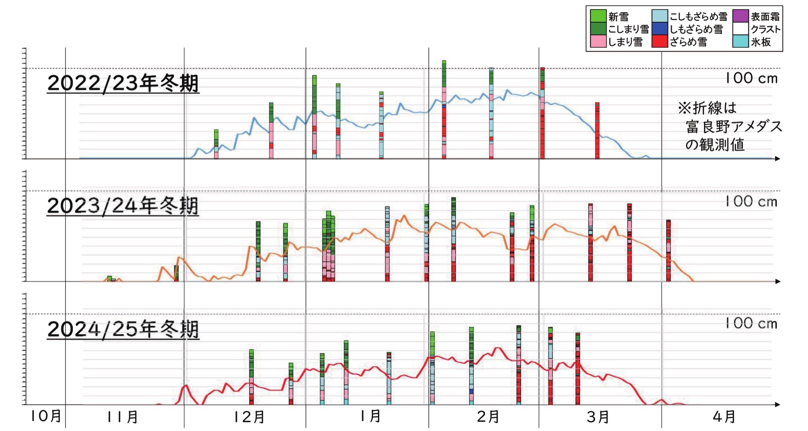
Snow changes through the season: from mid-February, warmer air brings more coarse, granular snow into the snowpack.雪はシーズンの中でも変わります。2月中旬以降は暖かい空気の流入で、粒の粗い「ざらめ雪」の割合が高くなります。
Checked against the real snow実際の雪で、確かめる
In winter 2022/23, modelled surface density was compared with six snow-pit measurements at the base of Furano Ski Resort. They tracked closely (r = 0.97), though the model ran about 22% lighter than measured — so the method is still being refined against field observations.2022/23年冬、富良野スキー場山麓での6回の積雪断面観測と、計算した雪面密度を比較。両者はよく対応しました(相関係数0.97)。一方、計算値は実測より密度が約22%小さく出ており、現地観測との照合を重ねて改良を続けています。
Source: Shirakawa, Matoba, Hashimoto, Yamasaki & Furano bonchi powder project, “Integrated evaluation of snow quality using the Fuwasara Index — application to Furano Ski Resort”. The Fluffiness Quotient does not describe snow depth or avalanche risk.出典:白川龍生・的場澄人・橋本明弘・山崎紋人・Furano bonchi powder project「降雪・積雪のふわサラ度®を統合した雪質評価 ― 富良野スキー場での応用 ―」。ふわサラ度は積雪の深さや雪崩の危険度を表すものではありません。
Why we don’t forecast the Fluffiness Quotientふわサラ度の「予報」をしない理由
Under Japan’s Meteorological Service Act, weather forecasts may only be issued by licensed providers. So we publish the Fluffiness Quotient for today only — from observed snowfall, or from the snow surface on days without snow — and show the Japan Weather Association’s forecast for the days ahead exactly as provided.気象業務法により、許可を受けた事業者以外は独自の予報を出すことができません。そのため、ふわサラ度は実況データにもとづく当日分のみを公開し、明日以降は日本気象協会の予報(天気・降雪量・降水量)をそのまま掲載しています。Under Japan’s Meteorological Service Act, weather forecasts may only be issued by licensed providers. So the Fluffiness Quotient will be published for today only — from observed snowfall, or from the snow surface on days without snow (now in preparation) — and we show the Japan Weather Association’s forecast for the days ahead exactly as provided.気象業務法により、許可を受けた事業者以外は独自の予報を出すことができません。そのため、ふわサラ度は実況データにもとづく当日分のみを公開します(現在、公開準備中)。明日以降は日本気象協会の予報(天気・降雪量・降水量)をそのまま掲載しています。
The Fluffiness Quotient describes snow quality — it is not an avalanche or safety rating. Heading into the backcountry? Check avalanche information and go with a guide.ふわサラ度は雪質の指標で、雪崩の危険度や安全性を示すものではありません。バックカントリーへ行く場合は、雪崩情報を確認し、ガイドと行動してください。
The scientists研究者
Who’s behind itふわサラ度を支える人
Read the contribution →寄稿を読む →
Read the contribution →寄稿を読む →
Read the contribution →寄稿を読む →
Fun fact: fluffy shaved iceこぼれ話:ふわサラのかき氷
At a kickoff event we served shaved ice topped with juice from the Furano Wine factory. Its Fluffiness Quotient? 77.キックオフイベントで、ふらのワイン工場のぶどう果汁をかけたかき氷をふるまいました。そのふわサラ度は「77」。
FAQ
Questionsよくある質問
When is the best time?いちばんふわサラな時期は?
When is it updated?いつ更新されますか?
Where is it measured?どこのデータですか?
What about days with no new snow?雪が降らなかった日は?
Is it the same as snow depth?積雪量とは違うのですか?
Why is there no score for tomorrow?明日のふわサラ度はなぜ出ないのですか?
Does the snow stay light after it lands?積もったあとも軽いままですか?
Can locals use it too?地元の人にも役立ちますか?
Hear it from the scientist研究者の講演を観る
Dr. Shirakawa’s special lecture, with English subtitles.白川先生の特別講演「富良野の雪の魅力に迫る」。